
Cao Bang to Ha Giang: Scenic Travel Guide
The route from Cao Bang to Ha Giang offers one of the most scenic and rewarding travel experiences in Northern Vietnam. From quiet borderlands to towering limestone mountains, every kilometer reveals something new. MOTOGO Tours proudly introduces this guide to help you explore the journey with confidence.

Introduction to the Northern Frontier
Vietnam’s northern frontier is defined by rugged mountains, border roads, and rich ethnic culture. At its heart, Cao Bang and Ha Giang offer raw landscapes and a timeless way of life for adventurous travelers.
General Characteristics of Cao Bang and Ha Giang
Cao Bang is known for its lush green karst mountains and the world-famous Ban Gioc Waterfall, creating an earthy landscape filled with hidden caves and peaceful lakes.

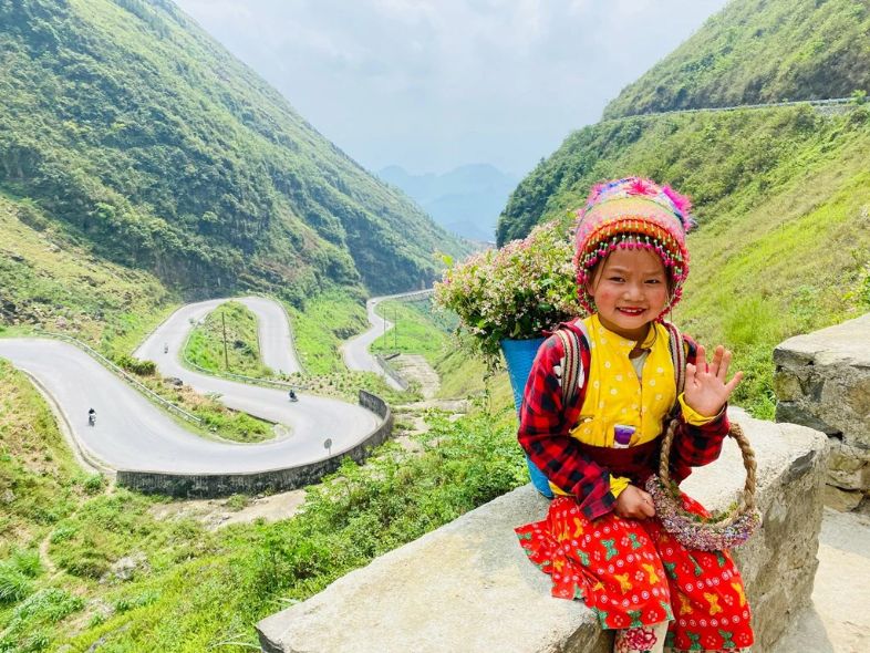
Ha Giang, by contrast, sits at a higher altitude and is defined by the dramatic limestone peaks of the Dong Van Geopark. Both regions are home to ethnic communities such as the Hmong, Tay, and Nung, whose vibrant markets and traditional stilt houses add cultural depth to the rugged mountains and rice fields.
Location and Distance: Measuring the Journey
Geographically, both Cao Bang and Ha Giang lie in Northeast Vietnam, stretching along the border with China. The distance between their provincial capitals is about 250–300 kilometers.
However, these are winding mountain roads, not highways. With countless hairpin bends, the journey often takes 7–9 hours, making it a full-day trip—so take your time and enjoy the scenery.
>>> The Ha Giang – Cao Bang Route: Northern Vietnam’s Ultimate Adventure
Best Ways to Travel from Cao Bang to Ha Giang
Choosing your mode of transport is the biggest decision you’ll make. Are you a thrill-seeker or a comfort-lover? Let’s break down the best ways to tackle this legendary path.
The Motorbike Adventure: Freedom on Two Wheels
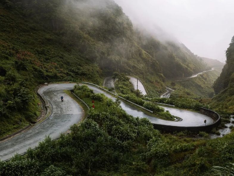
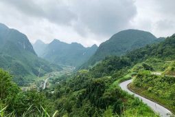
For adventure seekers, traveling by motorbike offers total freedom and an unmatched sense of scale. You ride with the wind, stop anywhere for photos or local food, and experience the mountains up close—though narrow roads and sharp curves mean this journey demands confidence and caution.

There are two main routes to choose from. The direct Bac Me–Bao Lac route is rugged and scenic but can be rough after rain, while the longer Dong Van–Ma Pi Leng route is safer and more dramatic, passing iconic mountain passes. Whichever you choose, plan fuel stops carefully, as gas stations are limited outside major towns.
Navigating by Local Bus: The Budget Traveler’s Choice
If you’re traveling on a budget, local buses are the most affordable option, costing around 300,000–350,000 VND. The journey usually involves a bus from Cao Bang to Bao Lac, followed by a transfer to Ha Giang.

It’s an authentic local experience, often shared with passengers carrying baskets of produce, but comfort is basic and English support is limited. The trip can feel like a small puzzle to solve, yet it’s a rewarding way to travel.
Limousine Services: Luxury in the Highlands
For a more comfortable, VIP-style journey, limousine vans are an excellent choice. These 9-seater vehicles feature plush leather seats and air conditioning, offering a smooth and relaxing ride.
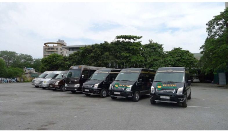
They usually run directly between the cities for around 400,000 VND, making them faster and far more comfortable than local buses—especially welcome after long days of exploring.
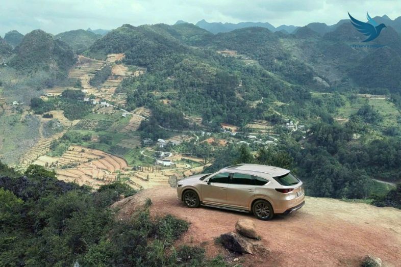
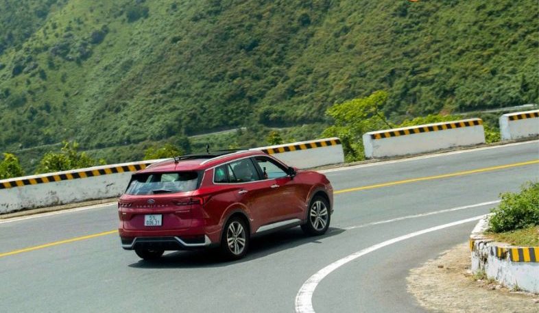
Private Car Hire: Comfort for Families and Groups
For families or small groups, hiring a private car is the most comfortable option. It offers the flexibility to stop at viewpoints or hidden cafés, combined with the safety of a professional driver. Prices typically start around USD 140–160, depending on vehicle size. While more expensive, the comfort, privacy, and peace of mind make it well worth the cost.
Easy Rider Tours: Expert Guides and Epic Loops
If you want the motorbike experience without driving, Easy Riders are a great option. These local experts take you on the back of their bikes, offering a safe and immersive way to explore the route.

They know hidden waterfalls, scenic viewpoints, and the best homestays along the way. Most tours last around five days and cover the full loop, including Ban Gioc Waterfall and the legendary Ma Pi Leng Pass.
>>> The Death Cliff in Ha Giang: Ultimate Travel Guide
Top Must-Visit Attractions in Ha Giang
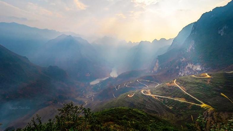
Ha Giang is not just a destination; it is a sprawling museum of geology and culture. Ha Giang motorbike tours allow travelers to experience every turn on the road, from canyons that drop into the abyss to ancient palaces hidden in the mist.
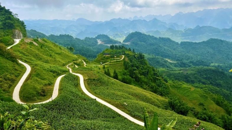
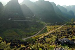
The Majestic Ma Pi Leng Pass
Often called the “King of Passes,” Ma Pi Leng is the crown jewel of the Ha Giang Loop. This dramatic 20-kilometer road clings to towering limestone cliffs at an altitude of around 1,200 meters, offering nonstop jaw-dropping scenery.
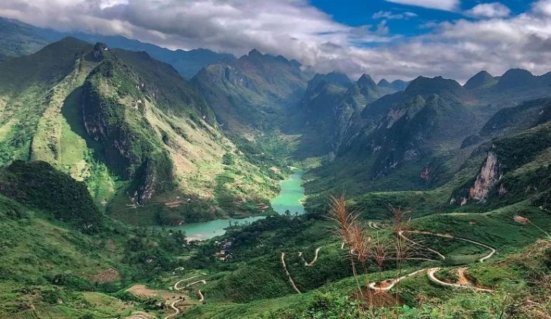
From viewpoints near the Ma Pi Leng Museum, you can look down on the emerald Nho Que River winding through the abyss. Below lies Tu San Canyon, the deepest in Southeast Asia, where boat trips or kayaking reveal the sheer 800-meter cliffs rising above the turquoise water.
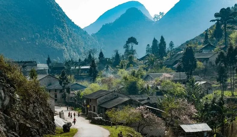
Dong Van Karst Plateau Geopark
Recognized by UNESCO, this vast “land of rocks” spans four districts, creating a surreal limestone landscape where local communities have learned to thrive among the grey peaks.

In Dong Van Old Quarter, century-old houses with yin-yang tiled roofs line narrow streets, and Sunday mornings come alive with a colorful ethnic market. For sweeping sunset views, a short hike to the ruins of the French-built fort overlooking the town is well worth the effort.
Lung Cu Flag Tower
Perched on Dragon Mountain (Nui Rong), the Lung Cu Flag Tower marks Vietnam’s northernmost point. After climbing nearly 400 stone steps, you’re rewarded with sweeping views that stretch across the border into China.
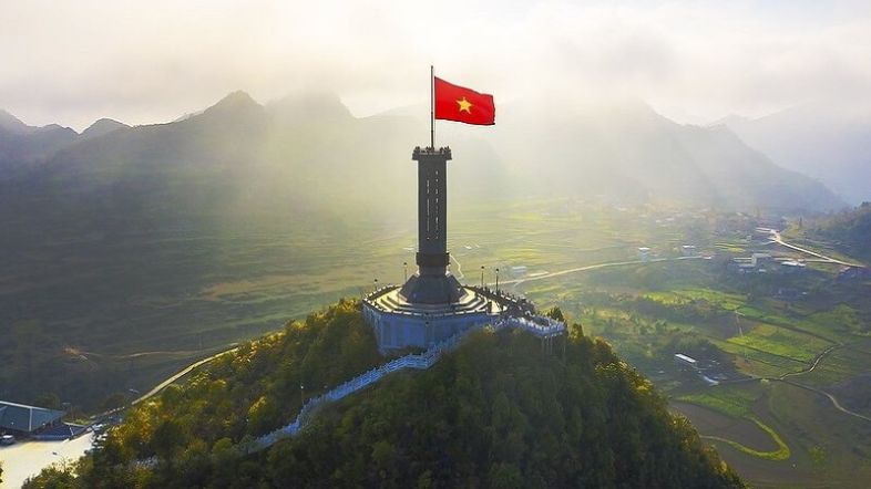
At the foot of the mountain lies Lo Lo Chai Village, a storybook settlement of the Lo Lo people. Its traditional earthen houses and warm hospitality make it an ideal place to stay overnight in a local homestay.
The Gates to the Highlands: Quan Ba & Yen Minh
Before reaching the high peaks, travelers pass through the legendary Heaven’s Gate. Quan Ba Heaven Gate is the first major viewpoint on the loop, offering sweeping views of the valley and the famous Twin Mountains, also known as the Fairy Bosom Hills.
Further on, the road winds through Yen Minh Pine Forest, often called the “Mini Da Lat” of the North. Towering pine trees and cooler air provide a refreshing contrast to the region’s rugged limestone landscape.
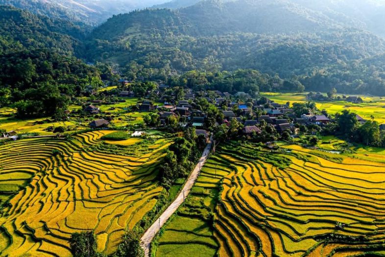
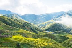
Sung La Valley: The Flower of the Plateau
Known as the most beautiful upland commune in Dong Van, Sung La Valley is celebrated for its fields of buckwheat flowers and blooming roses that color the plateau.
A key highlight is Pao’s House, a traditional Hmong home made famous by The Story of Pao. Today, it functions as a living museum, offering a glimpse into local daily life, from weaving to traditional cooking.
>>> Ha Giang Loop Route Difficulty Levels – A Complete Guide
Planning Your Trip: Weather and Timing
Navigating the high-altitude passes of Northern Vietnam requires more than just a map; it requires a strategy. Because the terrain is so rugged, the best time depends entirely on whether you are chasing golden rice fields, blooming flowers, or the sheer thrill of clear mountain views.
The Golden Window: September to November
Locals often say autumn is the most beautiful season in the north, making it the best time to travel from Cao Bang to Ha Giang. Cooler air, clear skies, and golden landscapes create ideal conditions for exploring and photography.
From September to early October, terraced fields glow with harvest gold, especially in Hoang Su Phi and Cao Bang. From October to November, pink and purple buckwheat flowers blanket the rocky plateaus, transforming the karst landscape into a vibrant floral scene.
The Bloom & Festival Season: February to April
Spring in northern Vietnam feels like a watercolor painting coming to life as the mountains awaken after Tet. The landscape turns soft and vibrant, with fresh air and a sense of renewal in every valley.
From February to March, white plum and pink peach blossoms bloom against dark limestone peaks. Spring is also festival season, with events like the Khau Vai Love Market in April, offering a rare glimpse into local traditions. The weather is mild, though morning fog can add a mystical touch to the journey.
The Emerald Edge: May to June
The emerald edge from May to June marks the “water falling” season, when early rains fill the rice terraces before the summer storms. During this time, the paddies reflect the sky like giant mirrors, and waterfalls especially Ban Gioc in Cao Bang regain their full power. While valleys can get hot, reaching up to 32°C, the mountain breeze keeps higher elevations comfortably cool.

The Stormy Challenge: July to August
The stormy challenge, from July to August, marks the peak of the rainy season in northern Vietnam. Heavy downpours can trigger sudden landslides and make mountain passes dangerously slippery, so motorbike travelers need to exercise extreme caution and remain flexible with their plans.
Despite the risks, this is when the landscapes are at their most dramatic. Waterfalls surge at full volume, clouds hang low in the deep canyons, and every view feels heightened—truly “Adventure Mode” at its peak.
>>> Ha Giang Weather: Best Time to Visit & Travel Tips
The Silent Winter: December to January
Winter in the northern highlands is a true test of spirit, with temperatures often dropping below 5°C and frost forming on the highest peaks. Travelers should come prepared with a heavy-duty windproof jacket and plenty of hot tea to stay warm.

The season brings a stark and moody atmosphere, perfect for quiet roads and “cloud hunting.” Late December offers a rewarding sight as yellow mustard flowers (rapeseed) bloom, adding bright splashes of color to the chilly gray landscape.
Essential Travel Tips for a Smooth Journey
Whether you are a solo backpacker or a family on a guided tour, these practical insights will help you navigate the logistical hurdles of Northern Vietnam.
The Paperwork and Legalities
- The Border Permit: Ha Giang is a sensitive border province. If you are a foreigner, you must obtain a “Permit for Entrance into the Border Area.” You can get this at the Immigration Office in Ha Giang City (200,000 VND) or ask your hostel/homestay to handle it for you. Keep this paper safe; hotels will ask for it during check-in.
- Driving Licenses: If you plan to rent a motorbike, an International Driving Permit (IDP) is legally required alongside your home license. Police checkpoints are common, especially near the start of the Ha Giang Loop.

Navigating the Terrain & Safety
- Check Your Brakes: The descent from Ma Pi Leng or the “Nine-Turn” pass is no joke. If you are on a bike or driving a car, make sure your brakes are in top condition. On motorbikes, never coast in neutral—use engine braking to stay in control.
- Fuel Strategy: Gas stations (Petrolimex) are common in district towns like Dong Van and Meo Vac, but they can be 50km apart in between. Never let your tank drop below 30%. In emergencies, look for “Cay Xang” signs or roadside houses selling fuel in plastic bottles.
- The “Golden Rule” of Mountain Roads: Honk before every blind corner. It’s the local “hello” that lets oncoming trucks know you are there.

Money and Connectivity
- Cash is King: While some high-end hotels in Cao Bang City take cards, the mountains are a cash-only economy . ATMs are sparse and often out of order in remote villages like Bao Lac or Du Gia. Carry enough VND to cover your food, fuel, and lodging for at least 3 days.
- Sim Cards: Viettel offers the best coverage in the highlands. Don’t expect 5G at the bottom of a canyon, but you’ll be surprised at how well you can get a signal at the top of a mountain pass. Download offline maps (Google Maps or Maps.me) as a backup.

>>> Let’s see more: How to Get an International Driving Permit (IDP) for the Ha Giang Loop
Cultural Etiquette and Respect
- Ask Before You Snap: The ethnic minority groups (Hmong, Lo Lo, Tay) are incredibly photogenic, but they are people, not props. Always or gesture ask for permission before taking a portrait.
- Dress Modestly: When visiting local homes or the Vuong Family Mansion, keep your shoulders and knees covered.
- Avoid “Candy Charity”: It’s tempting to give candy or money to children on the roadside. However, this encourages begging and keeps children out of school. If you want to help, donate books or clothes to a local school or through your homestay host.
Temperature and Comfort
- Motion Sickness: Even if you have “iron guts,” the constant hairpins can be nauseating. If you are traveling by bus or car, take a motion sickness pill 30 minutes before departure.
- The Layers Principle: Temperature can fluctuate by 15°C between a sunny valley and a misty mountain top. Wear a base layer, a fleece, and a windproof/waterproof outer shell.
- First Aid: Carry basic supplies for scrapes, as well as charcoal tablets (for the occasional “traveler’s belly” from spicy local food).

The journey from Cao Bang to Ha Giang is more than just a trip; it’s a rite of passage. It challenges you with its roads but rewards you with views that no camera can fully capture. Whether you’re flying through the air on a motorbike or reclining in a limousine, the spirit of the northern frontier will stay with you long after you’ve returned home. So, are you ready to pack your bags and head north?
Related Posts:
- Must-Visit Destinations in Ha Giang: A Comprehensive Travel Guide
- Top Things to Do in Ha Giang in December: Nature, Culture, and Winter Magic
- Tips for Solo Travelers and Group Tours on Alternative Routes in Ha Giang
- Best Things to Do in Cao Bang: Waterfalls, Caves & Local Culture
- Must-Try Dishes in Cao Bang: Top Culinary Experiences


Be the first to comment!